A few falls ago, my wife Monica and I tossed the dogs in the back of truck and made a day of checking out the changing aspen over by Mosca Pass and the Greenhorn Road. The first half of the day was great, with an uneventful drive and then a tremendous foliage display at Mosca Pass. The other half of the day was a bit more harrowing. I got us lost trying to get to the Greenhorn Road from Gardner. We ended up meandering through the San Isabel National Forest along twisty, rocky service roads for what seemed like forever and then by some miracle, we popped out onto the Greenhorn Road.

This autumn, word on the street was the aspen were due to peak during the first week of October, coinciding with Monica’s taking time off from work. I boldly suggested we once again drive deep into the San Isabel National Forest and check out the changing aspen. It’d be an ambitious trek: the Greenhorn Road by way of Hardscrabble Canyon and Highway 165 to Gardner, then head south toward Cuchara to the Cordova Pass and finally head home via Aguilar and Interstate 25. Surprisingly, Monica agreed. So along with my wife, our dog Rafa, and and all sorts of camera gear, I made sure my trusty Colorado gazetteer made the trip this time, along with a map of the San Isabel National Forest and a magnifying glass–don’t laugh–to insure we wouldn’t get lost in the wild yet again.
It was a brisk, breezy first morning of October as we made our way toward the mountains. And the route did not disappoint, nor did the aspen. The trees were resplendent in varying hues of yellows and greens and reds at every turn. The only damper on the day was the wind. It grounded my drone. But there were still plenty of pictures to be had on this trip.
At this point I suppose I should ‘fess up to having got a little off track coming into Gardner–I went left at what proved to be a crucial juncture, when right would have the better choice. I can’t explain how that happened with two detailed maps at my fingertips, but it did. I do feel compelled to argue, for the record, we weren’t really lost–we just weren’t sure where we were headed. We eventually came upon a road sign indicating that Highway 69, where we needed to get to, was nine miles ahead, affirming we were on the right path all the while.
Our place in the wilderness certain, we stopped for a quick lunch before heading south for the Cordova Pass.
The drive along Highway 12 just past Cuchara was probably the most spectacular leg of a dazzling day. Parts of the mountains were stands of pure gold. Honestly, my pictures don’t do it justice. It was so impressive that I dragged Monica back there two days later to get some aerial footage. Even then, I couldn’t match the show Mother Nature had on display. It was absolutely stunning.
A truck makes it way through a corridor of aspen along Highway 12 Oct. 3 2019 near Cuchara, Colo.Video by Mike Sweeney/©2019
We made the drive over the Cordova Pass to the Apishapa Arch without incident, stopping a handful of times to shoot photos. Surpisingly, the entire time Monica and I were off-road we only saw five other vehicles, one of which was a parked Forest Service truck whose crew was doing some trail maintenance.
We stopped at the Apishapa trailhead to stretch our legs and shoot the last photos of the day. Monica spotted a rather impressive hornet nest (just a tad bigger than a rugby ball) hanging from an aspen branch. The late afternoon sun was accommodating, breaking through some gathering clouds and lighting up hillsides quite nicely. As we wound our way toward Aguilar, we were treated to some wildlife, seeing a few deer and some turkeys along the roadside. Monica, showing off her eagle-eye once again, saw a bull elk with his harem of cows about 30 yards off the road. They quickly crashed though some brush and disappeared up a hillside, a fitting end to our day.
Capping off my aspen-themed week was a hike that Friday with my buddy Scott Smith up North Taylor Creek to Megan Lake in the Sangre De Cristo Wilderness (technically, a part of the San Isabel National Forest). Hikes in the Sangres with Scott have often struck with me bouts of altitude sickness, but having hiked to the top of Greenhorn Mountain (elev. 12,352 feet) with him in August–without incident–gave me the confidence to take on the eight-mile out-and-back North Taylor Creek trail (elev. 11,561 feet).
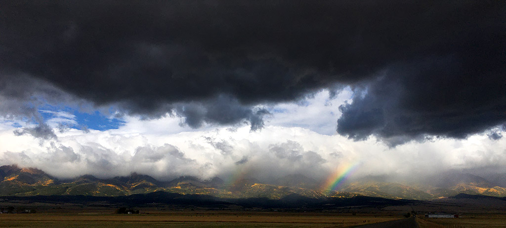
We were met with a dramatic display as we made the turn onto Custer County Road 170 on our way to the trailhead. A break in a light rain was just long enough to light up the Sangres, hugged by clouds and dotted in an aspen gold while a double rainbow made a lingering appearance. It was quite a sight. I snapped a photo with my phone while muttering that I should have brought along a real camera. We continued on, making a steady approach through a steady mist to the trailhead. It’s a rough four-wheel drive road and I was impressed that the Tacoma handled it with relative ease.
We made good time along the trail. And the possiblilty of getting lost never was in play because Scott’s a walking, talking gazetteer. It was cloudy and windy just about the entire day, except for the end. I didn’t dwell on the matter, but I was glad that the wave of nausea that’s ruined most hikes I’ve made in the Sangres never surfaced.
Aspen along the North Taylor Creek trail in the Sangre De Cristo Wilderness Oct. 4, 2019. Video by Mike Sweeney/©2019
I brought along a new piece of tech on the hike too, a Movi Cinema Robot. It’s a three-axis gimbal that stabilizes smart phone video. Scott wondered out loud, in a slightly snarky tone, if bringing a robot into a designated wilderness area violated some federal regulation. Undeterred, I put it to the test. It took a while to get it dialed in, but I managed to get enough presentable clips to put a short aspen-themed video together.
I was spent by the time I got home. Most folks don’t have the time to spend three days out of their week to spend in the high country looking at trees. I’m glad I can and that I did. I don’t know if I could do a fourth day, though. I was pretty much “aspened-out” by the time Saturday rolled around.